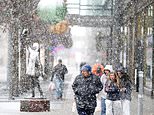
A powerful bomb cyclone is poised to affect millions of Americans, bringing severe winter weather across the Great Lakes and Northeast regions. As of December 29, 2025, meteorologists have issued multiple alerts, indicating that snowfall could reach up to two feet in the hardest-hit areas, particularly in parts of New York, New Hampshire, and Maine.
The National Weather Service (NWS) reports that over 30 million Americans are under winter weather advisories. This storm has already caused significant disruption, especially in the Midwest, where it has left more than 100,000 residents without electricity due to intense winds and heavy snowfall. The same weather system drenched California with rain and flooding just days earlier, illustrating its expansive impact.
Severe Weather Conditions Expected
As the storm moves eastward, it threatens major cities including Chicago, Detroit, Indianapolis, Pittsburgh, Washington D.C., Philadelphia, New York City, and Boston. AccuWeather meteorologist Brandon Buckingham emphasizes that travel conditions will deteriorate rapidly. “The storm will bring risks of heavy snow, ice, severe thunderstorms, powerful wind gusts, and heavy rain,” Buckingham stated.
Forecasts indicate that areas in the Great Lakes could see between six and ten inches of snow by December 30. Isolated locales may experience even higher accumulations. The storm is expected to strengthen quickly, with winds gusting at least 35 miles per hour from southwestern Minnesota to central Ontario. These conditions could lead to blizzard-like scenarios, with visibility falling below one-quarter mile for extended periods.
The wind advisories extend from the Ohio Valley to the Northeast, with gusts potentially reaching up to 55 miles per hour. More than 114 million people across the eastern United States are affected by high wind alerts, according to CBS News.
Travel Disruptions and Safety Precautions
AccuWeather has warned that cities such as Bangor and Portland in Maine, Albany and Binghamton in New York, Scranton in Pennsylvania, and Burlington in Vermont may experience light freezing rain late on December 29 into December 30. This could create icy road conditions, making travel hazardous.
The rapid pressure changes associated with a bomb cyclone are also expected to generate strong winds in areas not experiencing precipitation. Gusts of 40 to 60 miles per hour may disrupt air travel at major airports, including Chicago O’Hare and those in the New York City area, particularly on the night of December 29 into December 30.
As the situation develops, residents in affected regions are advised to remain vigilant and monitor weather updates from reputable sources like the NWS and AccuWeather. With the potential for extreme weather conditions, safety precautions are essential to mitigate risks during this powerful storm.